The United Kingdom:
Introduction to the UK:
- The British Isles consists of two large islands. These are called Great Britain and Ireland. It also includes 5,000 small islands around Great Britain and Ireland.
- Great Britain, the largest island, consists for 3 countries – England, Wales and Scotland. Ireland is divided into two countries – Northern Ireland and the Republic Of Ireland.
- The United Kingdom consists of the four countries of England, Wales, Scotland and Northern Ireland. The Republic of Ireland is an independent country and not part of The UK.
UK Climate
Factors that affecct UK Climate:
- Wind direction – Where the air comes from. A north wind will be cold, a west wind will be moist.
- Ocean currents – In winter, a warm ocean current called the North Atlantic Drift raises the temperature to the West.
- Latitude – In summer, the sun warms the south more than the North.
- Height – Temperatures are lower in hills and mountains by a 1° Celsius for every 100m in height. Britain’s uplands are in the North and West.
- Distance from the sea – The sea keeps costal places warm in winter but may cool them in summer. Places far inland have warm summers and cooler winters.
Rainfall
Key processes in the water cycle:
- Evaporation from oceans, lakes and streams
- Condensation
- Precipitation
Types of rainfall:
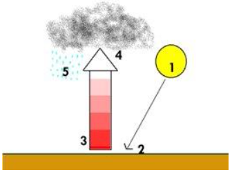
- Convectional rainfall – Sun provides heat source, heating the ground quickly. The air rises very quickly through convection. As the air rises, it cools rapidly. Large clouds develop as the air cannot hold as much water. Then torrential rain and thunderstorms are produced.
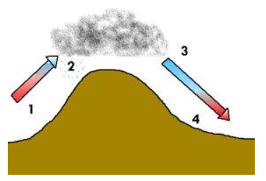
- Relief rain – Air is forced to rise over mountains which then cools. Water vapor in the air condenses and forms clouds and rains. Air descends and begins to warm again. Air has less water overall, clouds disappear and the rain stops. This side of the mountain is known as the rain shadow.
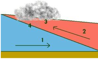
- Frontal rainfall – Colder air mass is denser so carries on pushing along the ground. As the warm air rises it cools and condenses, producing clouds. Warm air mass is forced to rise above the cold air mass. Further forcing of the air causes precipitation to form.
Anticyclones and Depressions
Anticyclones are areas of high pressure which form when air sinks. This means no clouds are formed and winds are weak. They move in a clockwise direction across the UK. Depressions are areas of low pressure which form when air rises. They usually move across Britain from West to East and bring most of our rain and cloud.
UK Multiculturalism
Multiculturalism is the presence of several distinct cultural or ethnic groups within a society. The ethnic mix of the UK has changed over time.

This data could be presented using a pie chart or a composite bar chart.
Economic Change:
The UK's economy has drastically changed over time. This data could be presented the same way as the data of the ethnic mix in the UK.
Most models are based on the UK’s economic development which took quite a long time to materialize. However, there are now new superpowers emerging that have developed much more quickly. An example of this is China.
Deprivation
To determine if a place or person is deprived (lacking access to something), the index of multiple deprivation is used.
The IMD uses 7 measures to help understand if a place is deprived:
- Living environment – Measures the quality of both the ‘indoor’ and ‘outdoor’ local environment. 9.3%.
- Income – Measures the proportion of the population experiencing deprivation relating to low income. Supplementary indices: Income Deprivation affecting Children Index – Measures the proportion of all children aged 0 to 15 living in income deprived countries. Income Deprivation Affecting Older People Index – Measures the proportion of those aged 60+ who experience income deprivation. 22.5%.
- Crime – Measures the risk of personal and material victimisation at a local level. 9.3%.
- Education – Measures the lack of attainment and skills in the local population. 13.5%.
- Barriers to housing and services – Measures the physical and financial accessibility of housing and local services. 9.3%.
- Health – Measures the risk of premature death and the impairment of quality of life through poor physical or mental health. 13.5%.
- Employment – Measures the proportion to the working age population in an area involuntarily excluded from the labour market. 22.5%.
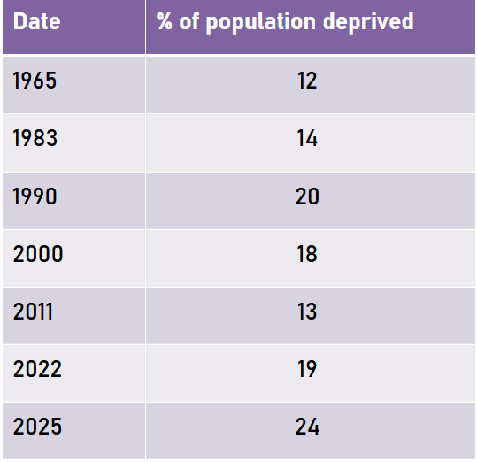
This data could be represented using a line graph.
The cycle of deprivation: This can start anywhere and some parts are interchangeable: Poor living conditions, poverty, ill-health, poor education, poor skills.
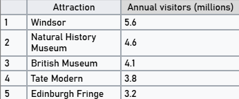
Tourism
5 most visited cities in the UK:

5 most visited attractions in the UK:
Africa
Africa's physical diversity
Africa will not have much precipitation at all in countries in deserts like Egypt. However, countries like Mali het 1120mm rainfall a year, whereas Egypt only gets 29mm on average.
Biomes are large-scale ecosystems with a similar climate and landscape, where similar animals and plants live. Biomes in Africa include rainforests, deserts, semi-deserts, grassland, savanna, and woodland/scrub.
Volcanic theory:
There are different layers of the Earth, there is the crust, the mantle, the outer core, and the inner core. Volcanoes commonly occur at a destructive plate boundary, when an oceanic plate subducts beneath a continential plate.
- The oceanic crust then melts as it enters the mantle because the mantle is extremely hot.
- The molten rock becomes liquid and rises because it will have a lower density than what is in the mantle.
- The molten rock fills magma chambers and when these are full and pressurized, they will burst, leading to lava bursting out of the ground.
- When the lava cools, it forms rocks, which is what is known as a volcano.
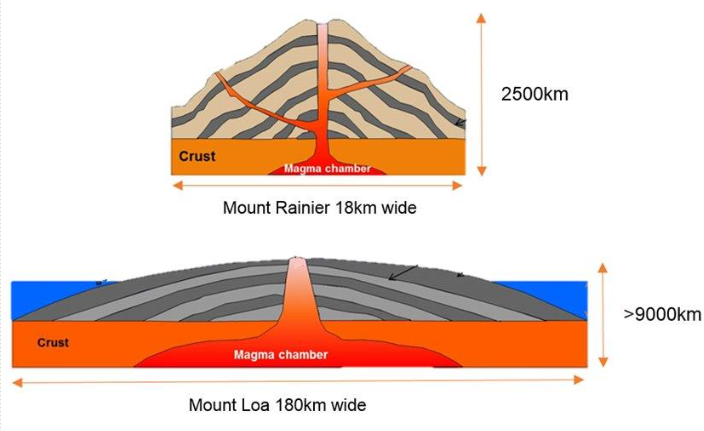
There are different shaped volcanoes that are created, depending on the lava type. If the lava is sticky, or in other words has high levels of viscosity, the lava will not run very far before cooling, creating a steep volcano – these are called composite volcanoes. Contrastingly, low levels of viscosity mean the lava will run further, creating flatter volcanes, which are called shield volcanoes.
Volcanic Hazards:
- Pyroclastic Flow is a dense, fast-moving flow of solified lava pieces, volcanic ash, and hot gases. A pyroclastic flow is extremely hot, burning anything in its path. It may move at speeds as high as 200 meters per second.
- Lahars are volcanic mudflows made of water, ash and debris. They move like wet concrete, often down river valleys, and can bury towns even long after eruption.
- Gas hazards from volcanoes is that volcanoes release gases like Carbon Dioxide or Sulfur Dioxide, which can harm health or even kill. Some gases form acid rain or suffocate life in low areas, posing serious risks to people and animals.
Lake Nyos:
Lake Nyos is in Cameroon. It is a volcano that had a crater formed by gas explosions in bedrock. Under usual conditionns the gas is held at the base of the lake by the water above. Volcanic gases including carbon dioxide seep upwards through the rock from underlying magma. As earthquake triggered a land slide which disrupted the lake water, allowing the trapped gas to escape. Estimated 1 billion meters cubed of carbon dioxide was released in one hour. Heavier than air, carbon dioxide flows down the sides of the volcano in a 50m thick cloud and into the valleys. 1700 people and 3000 cattle died. Animal life killed, including insects.
At least 10,000 people were displaced due to the Lake Nyos disaster. The priority of the Cameroon government and the United Nations was to allow these people back to their local area once the lake is deemed safe. This took 33 years. They could not let people go back until the lake was deemed gas free and safe, and this took way longer than anticipated. They were eventually allowed to return in 2019! A comprehensive de-gassing scheme was built. In 2001 a large pipe wa installed deep into the 200m lakee, where thee gas concentrated. Later, in 2011, 2 more pipes were installed as the process was taking too long. These pipes used a chemical reaction from the water and then extract the gas from the water. It w2as a slow, steady process, but the lake is now free of carbon dioxide, for now...
Urban Africa:
- Unregulated spaces often on the edge of the city, sometimes on a hillside, where lots of people will live, sometimes called a slum.
- They build their own house with resources they can acquire, often tin, tarpaulin, and wood.
- There is very limited access to water, sewage and electricity – often electricity is illegally syphoned.
- People will often complete informal jobs – cash in hand, unreliable hours, not taxed, low skilled.
- These settlements range in size, but some of them are so big they have a shopping network within them which provides jobs.
- Houses are sometimes built on top of each other.
Rural Africa:
Rural Africa often has limited infrastructure, with poor roads, unreliable electricity, and minima access to clean water and sanitation. Healthcare and schools are scarce and under-resource, and internet access remains spotty. Despite some progress, basic services and connectivity still lag far behind urban areas. Rural Africa typically has a young population, with high birth rates and a large proportion of children and youth. The population and density is generally low, with people spread across vast areas in small villages or farming communities. Many rural regions rely on agriculture, and households are often large and extended. While some areas are slowly urbanizing, rural populations still make up a significant share of many African countries.
Fairtrade:
An example of fairtrade: For a banana to get to the supermarket shelves, the following individuals/groups are involved:
- UK Supermarket
- UK Shipper
- UK Importer
- LIC Plantation Worker (LIC as bananas are mainly grown in such countries)
- LIC Plantation Owner (LIC as bananas are mainly grown in such countries)
For the sake of this example, a bunch of bananas costs £1. The stakeholders recieve:
- Plantation worker: 1p
- Plantation owner: 5p
- Shipper: 15p
- Importer: 35p
- UK Supermarket: 44p
Reasons why this is unfair is because the farmers and the owners are the ones doing the hard work, the manual labour, and the other stakeholders have their job much easier. Fairtrade can lead to an increased wage for manual labour workers, better health, education, skills, employment, children, meals, it can benefit them in many ways.
Middle East
The middle East can be seen as central on the world map but is slightly towards the East. There are 19 countries in the Middle East. They are Libya, Sudan, Egypt, Afghanistan, Iran, Turkey, Syria, Lebanon, Iraq, Kuwait, Jordan, Palestine, Israel, Bahrain, Saudi Arabia, Qatar, United Arab Emirates, Oman, and Yemen.
Arabian Desert:
The Arabian Desert is located mostly in Saudi Arabia, with most of the country covering it other than the south East, the North-East of Yemen, North-West of Oman, Kuwait, Qatar, South of the UAE, South-East of Jordan, and South of Iraq. It is not very far from the Mediterranean Sea, Red Sea, the Arabian Sea, and the Persian Gulf.
Sand dunes are mounds of sand that mostly form around an obstacle. The wind in a desert moves the sand across the vast open spaces, and in turn creates a variety of dunes within the landscape. Deserts have lots of sand as their primary rock is sedimentary, and over a very long period of time the wind errodes the rock, causing it to break down into sand.
The climate of a desert means there is limited biodiversity in a desert, and for the animals and plants that live there, there is absolute need for them to adapt to survive.
Camel adaptations:
- Fat stored in hump.
- Fur.
- Flat, padded feet.
- Leathery tongue.
- Nostrils that close.
- Long eyelashes
Date Palm Tree adaptations
- Deep roots.
- Fast growing and hard leaves.
- Long, thin trunk with spines/spikes.
- Leaves grow at top, not the trunk.
Syria and Turkey Earthquake

Syria and Turkey are in the top-left of the Middle East. These countries had an earthquake at the border.

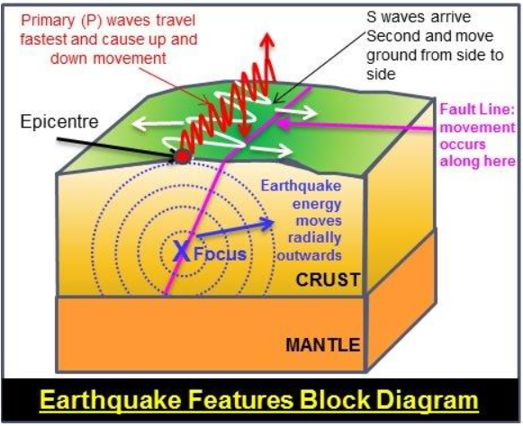
The epicenter is the point where the earthquake actually occurs. The focus is in the epicenter, the focus is where the earthquake is strongest, the epicenter is where the seismic waves come from.
Conservative plate boundary:
At a conservative plate boundary, 2 tectonic plates slide past each other, but due to friction, they often become stuck instead of moving smoothly. As the plates try to move, tension builds up over time becuse they are being forced in different directions. Eventually, the stress becomes too great, causing a sudden release of built-up energy, which is felt on the surface as an earthquake.
Components of an earthquake:
- Focus: The point inside the Earth where the earthquake actually starts – the rock breaks and energy is first released.
- Epicenter: The point directly above the focus on the Earth’s surface – usually where the shaking is strongest and most damage occurs.
- Primary waves: The fastest seismic waves that travel through solids and liquids, arriving first and causing back-and-forth motion.
- Secondary waves: These are slower than primary waves, and only travel through solids and cause side-to-side or up-and-down motion, often doing more damage.
Impacts:
- 18 million people affected by the quake
- 85% of medical centres were destroyed
- 56,683 people died
- 220,000 workplaces no longer in use
- Around 120,000 people injured
- Over 300,000 buildings damaged
- Damaged refugee camps – 50% of refugees in Turkey lost their home
- 11 agricultural areas of Turkey damaged, leading to extreme food shortages
Population and Migration
In the UAE, for example, many young men are migrating there to be able to work as there are many business opportunities in the UAE. Because of this, there is a huge gap between the amount of males and the amount of females in the Emirates.
Population at 1950

The cause of the rise in male working age population in the UAE (and many other Middle Eastern countries), and the small rise in women off this age is initially, oil – lots of jobs have been created in oil extraction which caused mass migration from a variety of countries, including HICs.


The average wage of these combined jobs is £70,000.
Note: It is not just oil and economic growth that has caused population change, the war in Syria has lead to lots of refugees and changes in population.
Syria: Conflict and Refugees:
- Groups within Syria were unhappy with the government due to the amount of unemployment and inadequate social services.
- These groups protested, and the government used deadly force to stop it.
- This led to mass protest for the president to resign, and the civil war started in 2011.
- A variety of countries are now involved in the war, including USA, Russia, France, and most Middle Eastern countries. Most of these groups are supporting the government with air strikes or army members.
- There are varying numbers of deaths given b different organizations, but most agree that over half a million people have died, with at least 150,000 of these caused by the government, and over 50,000 from torture chambers.
- As a result of the brutality of this war, lots of people have fled their home as they fear their life. These people are called refugees.
- 22 million people have sought refuge, with around 7 million internally displaced, and the others homed in different countries. A lot of these refugees are living in refugee camps.
- The UN states around 15 million people are still in need of support or refuge within Syria.
- Despite peace talks, and the Syrian government regaining control over main cities, the war shows no signs on ending just yet.
- Syrians in refuge have been displaced in many, many countries around the world.
- The majority of refugees will end up living in refugee camps, and there is a variance in the quality of these. Some are managed by the EU or charities such as the red cross, whereas others, over time, have become controlled by ISIS, a terrorist group.
Asia
Locational Physical Geography of Asia
- Asia is mostly in the northern hemisphere.
- The Middle East is located in the South-West of Asia.
- It is surrounded by the Pacific ocean, Indian ocean and the arctic ocean.
Central Asia, where the Himalayas are located, is what is surrounding the Plateau of Tibet.
The Himalayas:
- The Himalayas are the longest mountain range in the word. Mt. Everest is located in the Himalayas.
- Lots of habitats – vegetation and wildlife in the valleys.
- Poor people live in the Himalayas – nomadic farmers. Very welcoming. Shepherds.
- Subsistence farmers – getting food of their land.
- Glaciers – huge chunks of ice – water supply – inner Himalayas. These are melting and then rivers will form leading into the Ganges delta.
- Monsoon – hot temperature – short periods of rain.
- Himalayas has lots of fresh water for drinking.
The Gobi Desert:
- Mass desert region (one of the largest) in East Asia. 1.3 million kilometers squared.
- Very arid – less than 250mm annual rain. Harsh climate conditions.
- Bare rock, sand dunes, gravel plains and very limited vegetation.
- Scorching hot summer and really cold winters.
- Animals have adapted to the habitats.
- Nomadic farmers on camels, ‘ships of the desert’.
- Lots of ancient artefacts.
Ganges Delta:
- The rivers flow/discharge into the bay of Bengal.
- Surface area of 100,000 km squared +.
- Mainly Bangladesh, 1 third in India.
- Very flat and fertile land. One of the most fertile regions in the world.
- One of the most heavily populated regions.
- Has one of the largest mangrove forest.
- Suffered a huge cyclone, killing thousands.
How does the climate vary around Asia?
The 3 main climate regions found in Asia are:
- Polar – very cold and very dry – deserted.
- Arid – very dry and deserted
- Equatorial – Near/on the equator – rainforest.
Monsoon:
- The word monsoon means seasonal rain.
- 60% of people in the world live in an area that is affected by a monsoon climate.
- The percentage of a location’s annual rainfall can fall during the monsoon period is 90%.
- The temperature difference between the land and the sea at the beginning of the monsoon period is 20 degrees centigrade.
- The monsoon season starts at May and finishes at June/July (maybe on August) in India.
- It moves North to East.
- It does not continue into China and Pakistan because the Himalayan mountains trap the air.
- The place in the world with the highest rainfall totals recorded are the foothills of the Himalayas.
- The ratio of the rainfall the at the UK gets compared to NE India on average is 1:12.
- From March to May the strong sun heats up the land quicker than the sea.
- By the end of May temperatures on land are very hot whereas the seas remain 20°C colder. The warm air is less dense so rises. A low pressure zone is created which acts as a vacuum.
- The cooler moist air from the Indian Ocean is drawn up over the land to fill the low pressure zone.
- The moist air is forced to rise over the Himalayan mountains. The air cools and condenses forming heavy rain. The heaviest rain is in the foothills of the Himalayas which can be up to 12mm per year!
- As the sun loses strength during September and the land cools, the winds change and the next dry season begins.
A monsoon climate has a non-constant climate throughout the months while the equatorial climate has a relatively consistent climate compared to a monsoon climate. The temperature is similar but the monsoon climate has huge bursts of rain in a short period of time. The average rainfall in an equatorial climate is still much greater compared to the UK.
Monsoon season:
- 60% of global population affected by monsoon.
- Jetstream – strengthening area of high pressure in Indian ocean. Brings more moisture and energy.
- As high as 50 degrees.
- Winds push northwards.
- When air is forced to rise it condenses into a cloud.
- Severe flooding can impact people living in these areas and can affect companies economically.
- Dry season comes after wet season.
Mangroves:
Mangroves are found on coastal areas. Commonly found in South-East Asia and is also found in the North end of Oceania. Found in Mexico, North of South America and the Carribean Islands. Most mangrove habitats are on/near the equator.
- Mainly grows around tropical coastal areas: where freshwater meets saltwater.
- Soil is very soft, muddy and low in O2. Harsh conditions.
- Adapted to these conditions.
- Roots above and below the water and ground.
- Extend from trunks, stabilize tree in mud. Thick roots. Buttress roots.
- Roots grow upwards to be able to breathe.
- Excess salt kills trees so trees secrete them through their leaves.
- Propagules start growing immediately while still onto the tree, fall into water, absorb water for a few days until waterlogged. They sink and then grow with the soil.
- Indonesia has a fifth of all the Earth’s mangroves. 3 million hectares. The world lost 40% of its mangroves in the past 30 years. Less than 5% of the original mangrove forests are left.
- This is because of industrialization and urbanization.
- Absorb huge amounts of carbon.
- 1km squared of mangroves absorb as much CO2 as 45,000 cars
- We have more higher tides because of global warming. So these could be helping us a lot.
- Help with water quality.
- A mangrove is a wetland habitat that is found in tropical areas.
- Only 1% of the planet is covered in mangrove forest.
- They are found in 118 tropical and subtropical countries around the world.
- The largest amount of mangrove is fund in Indonesia – approximately 23,000 km squared which is an area twice the size of Jamaica!
- Mangrove trees range in height from 2—10m.
- There are 10 times more efficient at storing carbon than a traditional forest.
Effects:
- At up to 10m tall mangrove trees can act as a natural barrier to storm surge waves protecting local people in extreme weather events such as typhoons.
- As there are lots of resources available for hunter-gathers providing a sustainable food source e.g. honey from bees.
- Mangroves act as a carbon sink and are 10x better at removing CO2 from the atmosphere than other forests.
Economical:
- Local people can make a living from shrimp farming and fishing in the shallow waters.
- People living in the mangrove forest can earn a living from deforestation – chopping down trees to sell the wood for profit.
- People want to visit the mangroves on holiday to experience the unique environment. This provides lots of opportunities for local people to earn a living e.g. tour guides, jobs in hotels etc.
Environmental:
- The roots of mangrove trees help to trap sediment preventing the coast being eroded.
- High levels of biodiversity – 1500 species.
Why are mangroves environmentally sustainable?
- Mangrove forests have high levels of biodiversity (over 1500) species.
- The roots of mangrove trees create safe breeding grounds for small fish as larger predators cannot reach their eggs and young.
- Mangroves provide a habitat for many endanger3ed species such as humming birds, crocodiles and tigers – 15% of species in the mangroves threatened with extinction.
- Like all forests, mangroves covered CO2 and water into oxygen via photosynthesis.
- Mangroves are a major carbon store on our planet as their roots trap sediments allowing it to decompose which create rich, fertile soils.
Hazards — Tsunamis:
Tsunamis occur when the land meets the sea. Found on coastlines. High concentration in Asia, especially East and South-East Asia. Tsunamis occur on plate boundaries. The majority of tsunamis (approx.. 90%) occur in the Pacific Ocean. Lituya bay, Alaska, 09/07/1958 -- tectonic activity/ earthquake triggered a landslide – 1720ft/524m. Largest death toll from a tsunami over 289,000 from boxing day tsunami in 2004. A tsunami is a giant sea wave (means harbor wave in Japanese) caused by a displacement of water.
- They travel at speeds of over 700kmph.
- Out at sea they are only small in height (less than 1m).
- As they approach the shore they grow rapidly to heights of around 25m or more.
Here's how a normal wave works:
- Waves start out at sea and have a circular orbit.
- As waves approach the shore friction slows the base of the wave.
- This causes the orbit to become elliptical.
- Until the top of the wave breaks over, the sea bed is rough and acts as a source of friction.
And here's how a tsunami wave works:
- Tsunami waves are caused by sudden movements, usually from underwater earthquakes (majority because it’s 80%), landslides, or volcanic eruptions.
- Out at sea, tsunamis have a long wavelength and a lower wave height, so they often go unnoticed.
- They travel extremely fast – up to 500-800 kmph – in deep water.
- As they approach the shore, the wave slows down, and water piles up, causing the wave height to increase dramatically.
- Unlike normal waves, tsunami waves do not have a circular orbit and involve the movement of the entire water column, not the surface.
- When they reach the coast, they can flood inland with great force, often appearing as a rapidly rising tide or wall of water.
Rivers in Asia:
- The main rivers in Asia are the Yangtze, Ob', Mekong, Ganges and the Indus.
- The drainage basin is filled with water and it is where the river flows.
- It pushes out a way for the water to flow.
Drainage basin of a River:
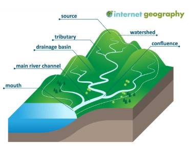
- The source of the river is where the water begins to flow from. The source is usually located in highland areas.
- The watershed of a river is the area of land that drains all the rainfall and streams into the river. It is also known as a drainage basin.
- A confluence is where 2 rivers meet.
- Tributaries are smaller streams that feed into the main river.
- The main river channel is the main path the river flows through. It carries water from tributaries toward the river’s mouth.
- The mouth is where the river meets the sea.
Long profile diagram:
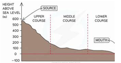
River Ganges:
River deltas:
- When sediments (load) form land.
- Water slows down and sediments formed.
- Sediments form rich land – load deposited.
- Colorado river, Mississippi and Nile deltas are famous deltas.
- Not all deltas are triangle shaped, some are bird shaped.
- Rivers like the Ganges transport large amounts of sediment from erosion.
- When the river meets the sea the channel becomes wider very quickly and due to the changing tides the water can be very shallow.
- Friction increases because of the shallow water.
- The river velocity falls.
- The river begins to deposit it’s load – the larger pieces first.
- Smaller pieces of sediment are carried further to sea.
- Sediment builds into a triangle shape as the total range in the bay is small.
- The river channel splits into smaller distributaries forming small islands called Eyots.
Russia Population:
The population density gets more at the west-side of Russia and lessens as you move more towards the East. There's more people near the key cities and near the rivers. Nobody lives right at the top of Siberia. This is because it is too cold in the Eastern part of Russia and general quality of life is better towards the West and the cities with lots of opportunities. Average January in Eastern Russia is –40°C in the winter. There’s lots of mountains towards the East and flatter land towards the West making agriculture easier.
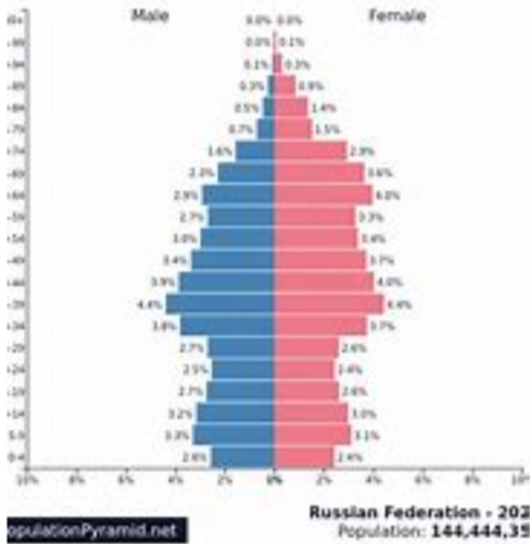
- Low birth rate and high death rate.
- Birth rate and immigration declines.
- There has been a decline in population because they have had a high death rate and a very low birth rate.
- This happened because women want equality and want to have good careers in their life without worrying to look after their children.
- The economy will decline if this keeps going on because there would be less people to pay taxes in the future.
- A Pro-Natalist policy is the policy in Russia where people will get added benefits and perks if they have larger families.
This scheme has been successful so far but we need to see in the future for a proper answer, and there is a war as well.
China's one child policy:
During the mid 20th century the Chinese people were encouraged to have large families to meet the philosophy that ‘a large population gives a strong nation’ which is a communist idea. This meant that every three years the population grew by 55 million people. In 1979, the government decided to try and control population growth. To do this they realised that a family should have no more than 1.5 children. Although this is impossible it takes into account that some families will have one pregnancy that results in more than one child e.g. twins or triplets.
Carrot policies:
- Free education for the child.
- Free contraception and family planning advice was available.
- Monetary benefits were given out e.g. bonuses at work, better jobs, better wages.
- People who only had one child were given the best houses known as ‘priority housing’.
- Higher retirement pay.
- Free health care was available for the whole family.
- Interest free loans were available.
Stick policies:
- It was made illegal to have children if you were not married.
- People who did not stick to the policy were not given the benefits and were given heavy fines.
- The legal age of marriage was raised to 22 for men and 20 for women.
- Women who became pregnant a second time were forced to have an abortion (even at the very late stage of pregnancy at 38 weeks).
- Couples were expected to apply for a marriage license and had to be granted permission to marry from the government.
- People who broke the rules were also made redundant and could even have their house taken away. The fines were also usually more than a family earnt forcing bankruptcy.
- Persistent offenders were ‘offered’ sterilization.
There is birth tourism, where children were born in another country and then brought back to China. Still, lots of illegal children were born. There was too many old people and not enough young. Then it was changed to a 2 child policy. Lots of one-sided propaganda. Lots of leftover men because couples did not want a girl as there only child. Another effect is 400 million births prevented.
Megacities:
There has been a significant increase in the number of megacities in the past 20 years and a change in the location of these. Asia accounts for at least half of thes4e. By 2030, approx. 9% of the world’s population will live in these megacities. The overall pattern is that most megacities are found in Asia. 9 of the top ten megacities are located in Asia.
Economic change:
Globalization is a term used to describe the world becoming more interconnected. There has been a gradual process from 1500 to present day, where as technology (communication and transport) has improved, the world has become more interconnected.
There has been improvements in technologies (Wi-Fi, transport, planes and containerization). Globalization is the increasing connection between people an places. People and places rely on each other – everything is becoming interdependent. Time-space compression is that the size of the world is metaphorically getting smaller.
Factories are moving from core countries to developing countries. This is because there are much cheaper labor prices there. What remains in the core countries are the headquarters because there is a more highly skilled workforce in those countries. The BRIC’s countries (Brazil, Russia, India and China) are expected to grow a lot. Exportalisation is where cheap new goods are processed into consumer goods for a high profit. Everything is becoming more interconnected.
How has China become the world's second largest economy?
- Biggest global importer.
- 50 years back, very agricultural and poor.
- 30% population in poverty 50 years ago
- Late 1950s, more profit from farming.
- 1980 – became a member of the world bank and international monetary fund.
- Overseas investment encouraged.
- Stock markets opened in Shanghai and Shenzen leading to massive increase in economy.
- 500,000,000 people lifted out of poverty over the past 50 years.
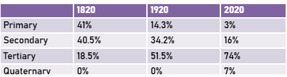
- 1978 – 47.7% in secondary, 24.6% in primary and 27.7% in the tertiary economic sector.
- 2022 – 2.5% primary, 32.2% secondary, 65.3% in the tertiary economic sector.
Transnational Corporations (TNCs):
A TNC is a corporation that operates in multiple corporations around the world. Their headquarters would be in a richer part of the world and factories are found in mostly Asia because of cheaper production costs and cheaper labor. Of £100 of clothes, the worker’s wages are very low. TNCs are getting high profits and the workers only get 0.4%.
80% of Bangladesh’s global exports is clothing. American companies are relocating to Bangladesh from China. Chinese factories are moving to Bangladesh because of cheaper labour.
Pros:
- Lots of growth in this industry.
- This industry is now worth around $21.5 billion.
- Workers can get holiday pay and earn overtime (if they are lucky).
Cons:
- 12 hours a day.
- 1 factory building collapsed with people in it – unsafe buildings. 1,130 killed/injured.
- Unsafe working conditions.
- Workers exploited.
- $63 a month.
North and South America
Introducing North and South America:
Biomes:
- Temperate forest – biome with moderate temps and distinct seasons with deciduous trees.
- Rainforest – Lush and dense biome with high rainfall and high biodiversity, dominated by towering trees, vibrant ecosystems in tropical or temperate climates.
- Taiga – A cold, coniferous forest with long winters and cold summers, primarily covered by evergreen trees like pines and spruces.
- Grassland – Open biome with lots of grasses and few trees. Moderate rainfall supporting vast plains and grazing wildlife.
- Chaparral – A biome with hot and dry summers with wild and wet winters. Has shrubs and small trees adapted to fire-prone conditions.
- Desert – A dry, arid biome with extreme temperature variations with little vegetation and organisms adapted to conserve water.
- Tundra – Treeless cold biome within frozen subsoil (permafrost) where hardly plants like mosses and lichens thrive in short summers.
Countries in North America
- Canada
- USA
- Mexico
- Guatemala
- Belize
- El Salvador
- Honduras
- Nicaragua
- Costa Rica
- Panama
- Cuba
- Jamaica
- Haiti
- The Dominican Republic
Countries in South America:
- Colombia
- Venezuela
- Guyana
- Suriname
- French Guinea
- Ecuador
- Peru
- Bolivia
- Brazil
- Paraguay
- Chile
- Argentina
- Uruguay
Introducing Rainforests:
Rainforest climate: In rainforests, the temperature stays stable throughout the year, ranging from 26°C to 28°C. There is rain all year with over 2000mm of annual rainfall. The rainfall isn’t absent but decreases in the summer months, not dropping below 50mm and then in the wet season, the average monthly rainfall is in the range between 250 – 300mm.
Rainforest layers (from bottom to top):
- Shrub Layer/forest floor: Little grows here except plants adapted to very low light. On the floor is a thin layer of fallen leaves, seeds, fruits and branches that very quickly decomposes. A leaf that might take a year to break down in normal climates will be gone in 6 weeks. The smallest animals include countless centipedes, cockroaches, scorpions, slugs, earthworms, and beetles. The largest include gorillas, anteaters and people.
- Understory/under-canopy: The understory usually reaches about 12 meters. It receives only 2 to 15% of the sunlight that the canopy gets. Many of the plants living in this level have adapted to growing in the shade and don’t need much light for photosynthesis. Understory plants have to find ways to advertise their flowers, so that the animals and insects can carry their pollen, can find them in the dim light. Jaguars, leopards and an abundance of insects reside in the undercanopy.
- Canopy: The canopy is a thick layer of vegetation 20 to 40 metres high. The leaves of the tree in the canopy generally have pointed shapes so that water will run off of them, this keeps the leaf surface dry and discourages the growth of mildew and mold. The leaves on these trees are also enormous to absorb as much sunlight as possible, some leaves can be 7 metres across. The canopy offers an abundance of shelter and food that many of the animals living in this layer neve need to descend from it e.g. monkeys and toucans.
- Emergent layer: Emergent are the tallest trees, growing 50 to 65 metres in height. There are only 1 or 2 emergent trees in every acre of forest. Between rainstorms, the climate here is often dry because of the bright sun and strong winds. Emergent trees cope with this brightness by producing tough little leaves whose small surface area and waxy coating keep evaporation to a minimum. Many emergent trees produce seeds with wings, so the wind can carry them away from the ground directly below, where they would be competing with the parent tree for food and water. Animals commonly found here are eagles, monkeys, bats and butterflies.
Deforestation in the Amazon
The rate of deforestation increased by 29% from the previous years. The price of beef increased in 2019, leading to vast quantities of rainforest cleared to raise their livestock and earn a profit. There are more soybean farmers because many people switched for milk alternatives because cow products were expensive. Soy farmers use old cattle ranches to grow their crops because they have easier access routes, forcing cattle ranchers deeper into the forest where they clear more land. Hydroelectric dams takes up a lot of space, so does the access routes and infrastructures. The forest code was changed by Brazil so it was easier to claim a deforestation license. One reason Brazilians may support deforestation is because deforestation and its uses earns the country a lot of money. The prices of products such as soy would increase if soybean farming was banned in Brazil because there would be a short supply but the same demand. What is meant by the term ‘biodiversity’ is the variety of life found in a place on Earth. The Amazon is known as the ‘lungs of the Earth’ because it has many, many trees, so it absorbs vast amounts of carbon dioxide, which is the biggest greenhouse gas, and it gives oxygen for everyone and everything to breathe. The Amazon is known as the "world's largest medicine cabinet” because it contains an incredibly diverse range of plant and animal species, many of which have medicinal properties. Scientists are keen to protect the amazon because there are likely to be many more undiscovered species and potential cures yet to be found.
Impacts:
- Less photosynthesis means more greenhouse gases will be in the atmosphere.
- Alternative uses of the RF account for 17% of Brazil’s income.
- 18% of endemic species extinct by 2020.
- Reduced water capacity makes soil dryer and less fertile.
- It is estimated the lost species from deforestation could have found the cure for most types of cancer.
- Loss of habitats for species.
- Loss of culture and land by indigenous people.
- US have experienced dryer periods because there is less transpiration.
- Over 15 international companies use the RF for their profit.
- 20% of the Amazon has been lost due to deforestation.
- 27% of the Amazon will be without trees by 2030.
- Soil erosion, reducing fertility.
- Dry, open land makes the RF susceptible to flooding.
Hurricanes:
The hurricanes are found between North and South America. Because of climate change areas North and South of the equator get more powerful hurricanes more often.
- Tropical storms start between the tropics where surface sea temperatures reach at least 26.5°C.
- Air is heated above the surface of these warm tropical oceans. The warm air rises rapidly under low-pressure conditions.
- The rising air draws up large volumes of moisture from the ocean, causing strong winds that circle around the eye.
- Additionally, as the air rises, it cools and condenses to form large cumulonimbus clouds, which generate torrential rainfall. Heat is given off when the air cools and powers the tropical storm.
- Cool air sinks into the eye. Therefore, there is no cloud, so it is drier and much calmer.
- The tropical storm travels across the ocean by the prevailing wind.
- When the tropical storm meets land, it’s no longer fuelled by the source of the moisture and heat from the ocean, so it loses power and weakens.
Parts of a hurricane:
- Eye: A region of mostly calm weather at the centre of tropical storms. The eye of a storm is a roughly circular area, typically 20 — 40 miles in diameter.
- Eye wall: A ring of towering thunderstorms where the most severe weather and highest winds occur. Wind can reach 150mph.
- Cumulonimbus Clouds: Clouds that form below 20,000 ft in a mushroom shape. They produce heavy rainfall because of their dense nature.
- Spiral rain bands: Elongated areas of heavy rain that spiral inward toward the storm’s centre. This is less destructive than the eye wall.
- Thunderstorms: A storm of heavy rain accompanied by lightning, thunder, wind, and sometimes hail. They are comprised of cumulonimbus clouds.
- Winds (size): However wide across the wind field measures (diameter) is taken as the size of the tropical storm.
- Outflow: Clouds at the top of the storm, losing energy as they spiral away from the eye.
Yellowstone Supervolcano:
A supervolcano is a volcanic eruption that is 1,000 times larger than a normal volcanic eruption. Super volcanoes are VEI 8. There are 20 supervolcanoes in the world.
The stages in the creation of a supervolcano:
- Caldera: Magma cannot escape to the surface and collects under the lower crust.
- An ‘uplifted bulge’ begins to form under the lower crust as the magma chamber enlarges.
- Cracks appear on the surface. Gas and ash erupt from the magma chamber through these cracks.
- The magma chamber collapses and a depression is formed. This is called a caldera.
Yellowstone is located within Yellowstone National Park, within the USA. The area of the caldera is approximately 1,600 square miles. The hot springs are regularly observed. Wyoming experiences 1,000 to 3,000 earthquakes per day.
The supervolcano erupted approximately 600,000 years ago. Recent research shows the ground has been uplifting 1.4cm a year for the last 50 years.
If it erupted
- Lava gets shot up into the sky and creates ash – it solidifies.
- People 1,000km away could die.
- Buildings collapse from ash build-up.
- Global temperature drop.
Mexico USA Migration:
Push factors are reasons that force people to move out. Pull factors are factors that attract people to a place/country.
Push factors of Mexico:
- Low-paid jobs – GNP = $3,750.
- Adult literacy rates 55% – poor education prospects.
- Poor medical facilities – 1800 people per doctor.
- Life expectancy – 72 years in Mexico.
- 47% unemployed in Mexico.
Pull factors of USA:
- Well paid jobs in USA (GNP = $24,350).
- Adult literacy rates 99% -- good education prospects.
- Life expectancy – 76 years.
- Excellent medical facilities in USA – 400 per doctor.
- Many jobs available for low-paid workers such as Mexicans.
Debate: Should we build a wall?
3 people FOR building a wall:
- Donald Trump: He thinks that they might smuggle drugs and they would take jobs from Americans.
- American citizens in California: Some may think it is necessary because of the idea that they might take jobs and/or they might have racist ideas.
- Border control because it could make their job easier.
3 people AGAINST building a wall:
- Claudia Sheinbaum Pardo (Mexican president) wouldn’t want it to be built because there’d be less tax paid and she would have to pay for it.
- Unemployed Mexicans wouldn’t want it to be built because then they wouldn’t have a chance of getting a job.
- American business owners because they wouldn’t want to get less customers AND there are people who are needed to fill in for lower-skilled jobs.
Living conditions in Rio De Janeiro:
- Living conditions in Rio: Favela – usually informal settlements. Poor infrastructure and facilities. Has not planned as city for climate change. Most favelas are in high crime areas. Barely any police or government in favelas. Lots of bullet holes in wall from weapons including rifles. Tres provide shade in some areas of favelas. Roots of trees bind soil together to reduce the risk of landslides.
- Problems with deforestation: Lack of greenery and green spaces. 85% of primary Atlantic forest gone due to infrastructure. 1 in 50 of all Earth’s plants and animals are here. Very tall trees – only little left because of boats needed. Mystery illness losing 33% of Tasmanian devils in a few months. Yellow fever. Forests cut into smaller sections.
- How deforestation is being managed: High-tech center. Focused on combating climate change. A lot of the Atlantic forest has efforts put in to be regrown. Bridges built to unite forests.
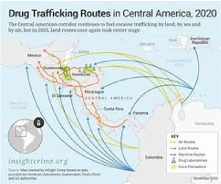
South America Drug Trafficking:
The sourcing, creation and distribution/sale of drugs that are subject to drug prohibition laws. Argentina and Chile are not making a lot of drugs. Neither the smaller countries Northeast of Mexico. 60% of all cocaine in South America is produced in Colombia. And Guyana, Surinam and French Guinea.
- Dangerous areas in Central America because of gangs.
- Guatemala and Honduras are some of the most violent places in the world and have lots of asylum seekers.
- Cocaine produced in the Andes Mountains stretch from Bolivia to Colombia.
- Cartels overpowering governments.
- Cartels sending drugs distributing it to Florida through the Carribean.
- George Bush Sr. Spent $1.5 billion (not accounting for inflation) to stop the Carribean route.
- 1990s – cocaine transported through Mexico.
- Corrupt Governments in Guatemala and Honduras bribed by cartel after civil wars.
- 2000s – U.S. and Mexico had an attempt on cracking down the drug route.
- 2014 – Obama helps Guatemala and Honduras to crack down on the drug route.
- These countries have the same death rate as Iraq and Afghanistan in wars.
Impacts:
- Around 50 billion USD was spent on measures to prevent drug trafficking. This comes with the help of many different countries.
- Violence in Ecuador has caused homicides to increase by an average of 86.3% per year every year for the last ten years.
- 34,000 murders a year in Mexico related to drugs.
- Drug sales make 25 billion USD a year on average.
- Production and cultivation of drugs has caused over 10,000 hectares of rainforests deforested and local water sources contaminated by chemicals.
- High unemployment rates leads to drug involvement in South America.
- Many drugs in favelas because jobs are often not given to people living in favelas.
- Farmers on borders are quite upset in the US.
Introducing Rio De Janeiro
Located at the South-East of Brazil. On the coast, near cities like Sao Paulo, Campinas and Belo Horizonte. Parts of it look industrial but it has some economic inequality.
Significance of Rio on a regional scale:
- It is home to many universities and research centres drawing in people from across the region.
- It has the 30th largest GDP for a city in the world at 201 billion USD.
- It is a finance centre for the regional area.
Significane of Rio on a national scale:
- Brazil’s second most important industrial centre, producing 5% of Brazil’s GDP. They manufacture pharmaceutical, chemicals, clothing, furniture and processed food.
- It is the cultural capital of Brazil with 50 museums (also international importance).
- The Brazilian stock market is located in Rio de Janeiro.
- 17% of the scientific research in Brazil originates in Rio de Janeiro.
- Major multinational and national companies have their headquarters in Rio de Janeiro including O Dio the national newspaper (also international importance).
Significane of Rio on an international scale:
- 2016 Olympic Games.
- It is a major port which exports coffee, sugar, and iron ore. It actually has 5 ports and 3 airports.
- Christ the Redeemer is one of the new seven wonders of the world.
- 10.49 million international tourists visit each year to see the stunning beaches and attractions such as Christ the Redeemer.
- It is famous worldwide for carnival, a celebration of music and dance.
- It is a UNESCO World Heritage Site.
- Grupo Globo the largest telecommunications and media company is located in Rio de Janeiro.
Rural Urban Migration
- In rural areas, life is hard.
- Moving to the city, there are lots of economic opportunities.
- Standard of living is good.
- Push factors – life is hard, struggling as a farmer.
- Pull factors – things that attract people to move there.
Carribean Tourism:
Why people visit the Carribean:
- Sandy beaches.
- The culture.
- Rainforests.
- Hotels.
- 7,000 islands.
- Tropical climate.
- Best to go December — April.
- Indigenous people.
- Lots of festivals.
- Carnivals.
- Scuba diving.
- Sailing.
- Waterfalls.
Top 3 most popular places in Carribean (2022):
- Dominican Republic.
- Puerto Rico.
- Jamaica.
Impacts:
- Social impacts:
- Positive: Tourists enjoy their time there. They can also learn about the Carribean.
- Negative: It can create divides in the community — economic inequality. Also, these jobs are only seasonal.
- Economic impacts:
- Positive: Lots of money from Tourism. Many jobs are created.
- Negative: Lots of money is invested, it is very expensive. Cruise ships get much more money anyways.
- Environmental impacts:
- Positive: Rainforests, Beaches protected (being worked on).
- Negative: Deforestation, pollution from transport, lots of water pollution from litter people leave as well.
- For every 100,000 USD invested in the Caribbean tourism industry, 50 jobs are created.
- The Caribbean has many tourists from cruise ships, with 1/3 of all cruise liners frequenting the Caribbean. This is increasing year on year and currently equates to over 30 million.
- However, these do not stay over on the island, so they do not spend as much as those who stay in hotels on the island. Instead, the cruise ship company get the profits (economic leakage).
- Tourism revenue that goes back into the economy is mixed. 95% goes back from ecotourism, only 20% goes back from package holidays, which most of the Caribbean tourism is.
- Tourism accounts for over 1/3 of the Caribbean’s GDP, which is around $60 billion.
- 90% of Antigua and Barbuda’s GDP is from tourism.
- There are 2.5 million jobs in tourism across the islands, which is 12% of all employment. This is the highest percentage of tourism-based jobs in the world.
- Most of these jobs are seasonal, as the climate is not conductive to tourism all year round.
- Tourism creates a lot of water pollution. 2014 litter items are found per kilometre in the Caribbean Sea. This is reducing biodiversity levels of marine life, which is a key tourist attraction.
- Tourism can create divide in the country. Tourist hotspots are developed as they are heavily invested in to, and then areas without tourists do not see investment leaving people in these areas in poverty.
- Ecotourism is a sustainable form of tourism. It tries not to damage the environment and respect local culture and customs.